
About This Park
With 562-acres, Little Beaver State Park offers family fun, beautiful scenery and incredible outdoor recreation. The park features nearly 20 miles of trails to explore and an 18-acre lake where anglers may fish year-round. Stand up paddle board, kayak, canoe and paddleboat rentals are available seasonally. Park visitors can also enjoy biking, picnicking and camping at Little Beaver.
Accommodations
Select an option below to learn more about the accommodations at this park.Activities
Select an activity below to learn more-
ATV
ATV
The New River Gorge region crawls with off-road trails. Contact a local outfitter for rentals and guided trips through the wilderness! While ATV use is not permitted in the park, Little Beaver State Park is the perfect place to unwind after an exciting day on the trails!
-
Biking
Biking
Bring your bike to Little Beaver State Park where different levels of trails available for mountain biking await. Pick up a map of the trails at the park office before you head out!
-
Boating
Boating
Rent a boat and explore Little Beaver’s 18-acre lake. Stand-up paddle boards, kayaks, canoes and paddle boats are available seasonally.
-
Camping
Camping
Little Beaver State Park’s campground has 16 sites with water hookups and 30 with electric and water. The campground features a large bathhouse with laundry facilities, a central dump station, wireless Internet access at the camp store, picnic tables and grills. Firewood and ice are available for purchase upon your arrival.
Group Camping
Little Beaver State Park also has a large, primitive group camping area that can accommodate up to 50 guests. Note: Little Beaver State Park campground is seasonal by nature. The campground is open April 1 to November 1, weather permitting.
-
Fishing
Fishing
The 18-acre lake at Little Beaver State Park offers bass, channel catfish, crappie, carp, bluegill and trout fishing. But before you head out, make sure you purchase a current West Virginia fishing license, available at www.wvfish.com.
Fishing in Little Beaver State Park
-
Golf
Golf
Can’t live without golf? Twin Falls Resort State Park is the place to go. Challenge yourself on the 18-hole championship green or tackle the tricky 9-hole course. Cart rentals and lessons are available.
-
Hiking
Hiking
Breathe in the fresh air on a hike through 17 different trails at Little Beaver State Park! You’ll feel de-stressed and refreshed in no time.
Download Park Pack & Map -
Outdoor Adventures
Outdoor Adventures
Get out on the lake and enjoy the feel of real mountain bliss. Paddleboats, rowboats, canoes and kayaks are available for rent.
-
Rafting
Rafting
The New River Gorge teems with world-class whitewater. Contact local outfitters for guided trips on mild—or wild—rapids.
Contact
- Phone: 304-763-2494
- Email: dnrlittlebeaver@wv.gov
- Address: 1402 Grandview Rd., Beaver, WV 25813
History
Little Beaver State Park was established in 1972 as a day-use park, but the site had been a recreational attraction for 4-H campers and anglers since the 1940s when the damming of Little Beaver Creek created an 18-acre lake. In 2011, the park was upgraded with 46 camping sites, expanding opportunities for this popular family reunion and vacation destination.
Camping
Little Beaver State Park’s campground has 16 sites with water hookups and 30 with electric and water. The campground features a large bathhouse with laundry facilities, a central dump station, wireless Internet access at the camp store, picnic tables and grills. Firewood and ice are available for purchase upon your arrival.
Group Camping
Little Beaver State Park also has a large, primitive group camping area that can accommodate up to 40 guests. There is a per-night rental fee. A reservation is required prior to set up.
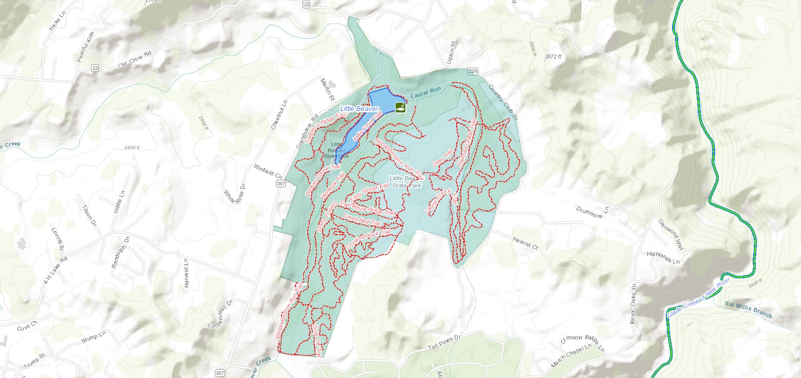
Trails
Download Park Trail MapBeaver Creek Trail
Billy Goat's Gruff
Creek Bed
Crooked Rock Trail
Deer Trail
Drop Off
Easy Street
Hemlock Trail
Laurel Creek
Lake Front Trail
Nature Ridge
Railroad Grade
Rhododendron Run
Stone Trough
Topper's Ridge
Turkey Spur
Weaver Way
Additional Information
Picnicking
Choose Little Beaver State Park for your next get-together! There are five picnic shelters and other picnic areas with tables and grills that can accommodate family reunions, birthdays and other gatherings. Playgrounds are available for the little ones as well.
Disc Golf
An 18-hole disc golf course is coming to Little Beaver State Park. Check back for updates.
Nearby Attractions
Tamarack
Come to Tamarack for “The Best of West Virginia”. Located at Exit 45 near Beckley, this is a must-see stop for its uniquely West Virginian crafted art, gifts, food products and more.
Winterplace Ski Resort
Located in Ghent, on Raleigh County’s Flat Top Mountain, Winterplace is West Virginia’s southernmost ski resort. This popular winter attraction has 90 acres of slopes, and is a short drive off Interstate 77.
Glade Springs Resort
Located a few miles from Interstate 64 and 77, Glade Springs Resort offers a variety of recreational activities, like golfing, skiing, fly-fishing and horseback riding. It also has a full-service spa, state-of-the-art conference and meeting facilities and lodging accommodations all at your fingertips.
Beckley Exhibition Coal Mine
Go back in time at the Beckley Exhibition Coal Mine! Visitors may tour an underground mine, coal camp, and museum. The hands-on exhibitions and underground coal mining tour offer wonderful opportunities for visitors to learn, explore and interact with West Virginia’s history.
Grandview National Park
Located about 10 miles from Beckley and part of the New River Gorge National River, Grandview is a peaceful place to relax and unwind while enjoying outstanding views.
Theatre West Virginia Outdoor Dramas
Theatre West Virginia offers dramas and musicals in an outdoor amphitheater with the dramatic views of the New River Gorge serving as its backdrop. The amphitheater is located near Grandview in Beaver, and is open during the summer.
Twin Falls Resort State Park
Visit Twin Falls Resort State Park, one of West Virginia’s 10 lodge parks! The park offers hiking and mountain biking trails, as well as golfing and tours of a pioneer farm.
Babcock State Park
Babcock State Park’s famous Glade Creek Grist Mill is just 21 miles southeast of Hawks Nest State Park on U.S. Route 60. It offers a lake for fishing and boating, hiking trails, and campgrounds and cabins.
Hawks Nest State Park
This 276-acre park with a lodge and restaurant is known for its scenic overlooks of the New River Gorge. Visitors can ride the aerial tramway to the bottom of the gorge and ride a jetboat to the base of the New River Gorge Bridge.
Bluestone State Park
Bluestone State Park is best known for its variety of water-oriented activities on Bluestone Lake, West Virginia’s third largest body of water. One day out on this lake will have you returning for many more!